2.1.0 The Rock Beneath Review

Unit 2 · Physical Elements · Lesson 2.1

The big idea Earth’s inside is always moving. That movement reshapes the crust, creates landforms, and causes hazards that affect where and how people live.
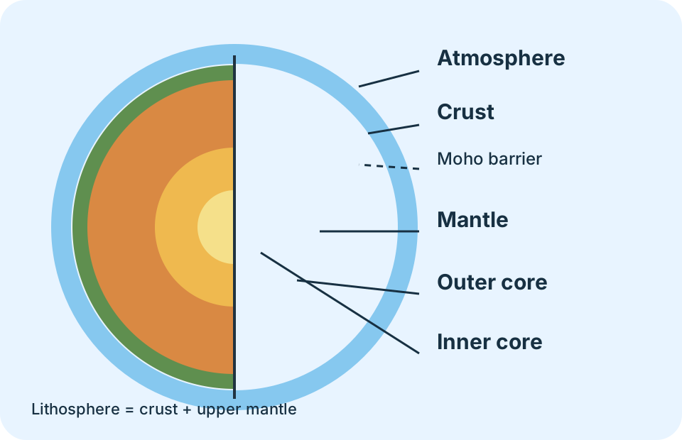
Cutaway diagram of Earth showing the atmosphere, crust, mantle, outer core, and inner core

By the end you can

  • Describe Earth’s layers and explain how convection in the mantle affects the crust.
  • Identify major landforms and connect them to crust movement, volcanism, erosion, and deposition.
  • Explain plate interactions, continental drift, and why the Ring of Fire has earthquakes, volcanoes, and tsunamis.
  • Compare the risks and benefits of living near the Ring of Fire.
The whole lesson in one chain

The Rock Beneath connects what happens inside Earth to the landforms and hazards people see at the surface.

Not sure about the basics underneath this lesson?

Earth is built in layers

The atmosphere is the gaseous envelope around Earth. Beneath it, the crust is Earth’s thin outer surface. Oceanic crust lies under the oceans and is thinner than continental crust, which contains the continents.

Earth is built in layers (2)

The mantle lies between the crust and the core and extends about 2,900 kilometers below the crust. The crust plus the upper mantle form the lithosphere. The Moho barrier is the boundary between the crust and mantle.

Earth is built in layers (3)

The core is nearest Earth’s center. Its outer part is liquid and its inner part is solid because intense pressure keeps it from melting. Movement in the core creates Earth’s magnetic field.

Earth layers from the atmosphere to the inner core
From outside to inside: atmosphere, crust, mantle, outer core, inner core. The Moho separates crust from mantle.
Likely on the quiz Do not confuse crust with lithosphere. The lithosphere includes the crust and the upper mantle.
Not sure about this bit?

Convection moves the surface

Convection transfers heat through material. Temperature differences create density differences: hotter, less-dense material rises while cooler, denser material sinks. This slow cycling moves rock in the mantle.

Convection moves the surface (2)

Mantle movement pushes and pulls the crust. Most crust movement is extremely slow, about as fast as fingernails grow, but faults can slip suddenly during an earthquake. Movement below the surface builds mountains, feeds volcanoes, and changes human settlements.

Likely on the quiz The study sheet’s chain is temperature difference → density difference → convection → mantle movement → crust movement.

Recognize the landforms

Mountain: land that rises sharply. Volcano: an opening that releases magma, ash, and gases. Valley: low land surrounded by mountains or hills. Canyon: a deep valley with steep sides. Glacier: a large mass of ice moved by gravity.

Recognize the landforms (2)

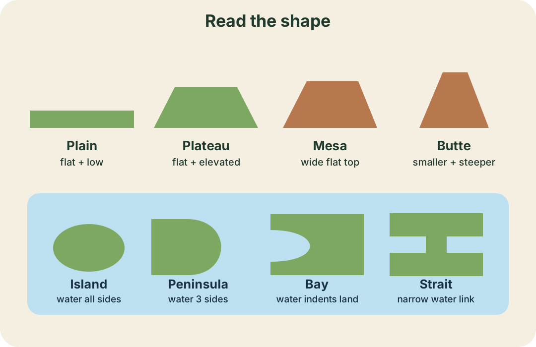
Plain: flat, low land. Plateau: elevated flat land. Mesa: a wide, flat-topped hill larger than a butte. Butte: an older, smaller formation with steeper sides.

Recognize the landforms (3)

Bay: a large shoreline indentation. Strait: a narrow waterway joining two larger bodies of water. An island has water on all sides; a peninsula has water on three sides; a cape projects into water; and an archipelago is a chain or cluster of islands. A delta is deposited material at a river mouth. A swamp is a flooded area with woody vegetation.

Comparison drawings of a plain, plateau, mesa, butte, island, peninsula, bay, and strait
Use the outline and the water around it to tell similar landforms apart.
Likely on the quiz A plain and plateau are both flat, but the plateau is elevated. An island has water on every side; a peninsula stays attached to the mainland.
Not sure about this bit?

Four processes shape land

Most landforms are produced by one or more of four processes: movement of Earth’s crust, volcanic activity, erosion by water, wind, ice, or gravity, and deposition of sand or soil by wind or water.

Four processes shape land (2)

Volcanoes can destroy communities, but lava also creates new land. Soil building happens as rock particles and dead plant and animal material collect. In the Great Plains, rivers carried silt into a shallow sea. Later, plant roots held the soil and dead plants added more material.

Likely on the quiz Erosion carries material away. Deposition drops it somewhere else. A sandy cape at a river mouth points to deposition.

Plate boundaries make different features

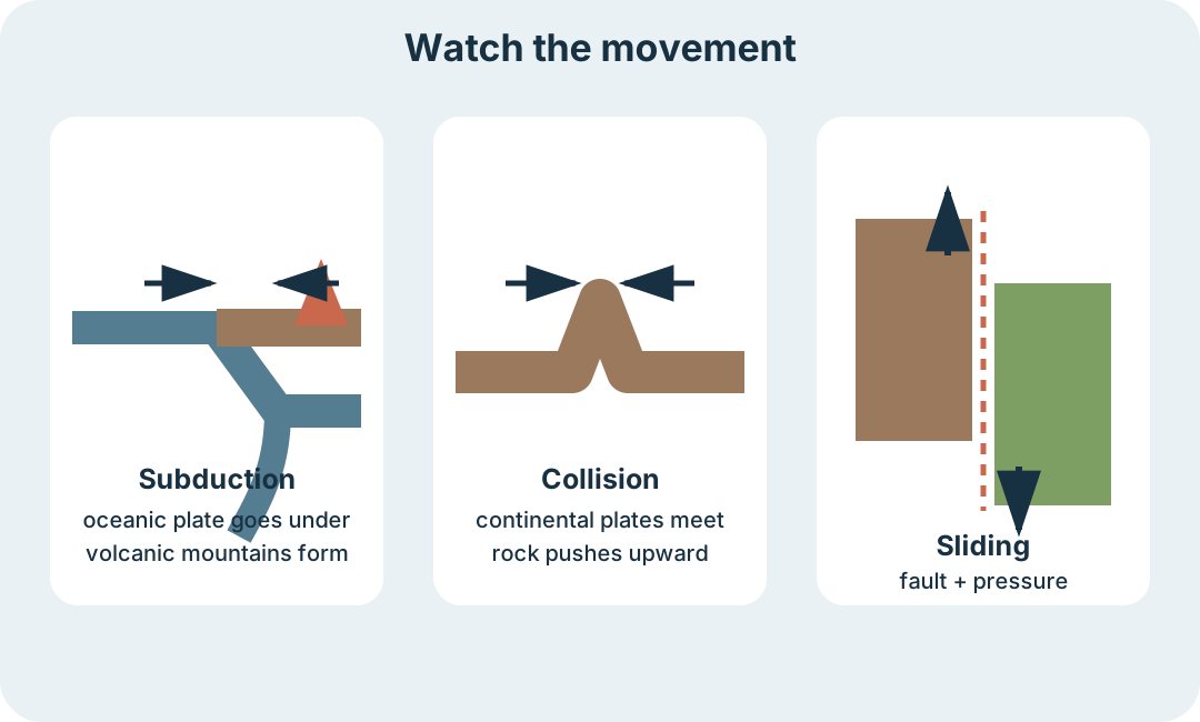
Earth’s crust is broken into tectonic plates. When a thinner oceanic plate meets a continental plate, the oceanic plate can slide underneath at a subduction zone. It heats up, magma rises, and volcanic mountains form.

Plate boundaries make different features (2)

When two continental plates collide, neither easily sinks. Rock is pushed upward into mountains, as India’s collision with Eurasia formed the Himalayas. When plates slide past one another, pressure builds along a fault until it slips and causes an earthquake.

Plate boundaries make different features (3)

The Nazca Plate is pushed beneath the South American Plate near the Peru-Chile Trench. That plate interaction created the Andes. Along California’s San Andreas Fault, the Pacific Plate moves north beside the North American Plate. California moves; it does not fall into the ocean.

Three plate-boundary diagrams showing subduction, continental collision, and plates sliding past each other
Subduction makes volcanic mountains, continental collision pushes mountains upward, and sliding plates produce faults and earthquakes.
Likely on the quiz Match the motion first: under = subduction, together and up = mountains, past each other = fault and earthquake.
Not sure about this bit?

Continents drift

Continental drift is Alfred Wegener’s theory that continents move over time because they ride on tectonic plates. Continents move only about two centimeters per year.

Continents drift (2)

About 200 million years ago, the continents were joined in the supercontinent Pangaea. The surrounding ocean was Panthalassa. The fit between continental shelves and the Mid-Atlantic Ridge helped support the idea that the continents separated.

Likely on the quiz Pangaea was land. Panthalassa was the ocean around it.

Why the Ring of Fire burns

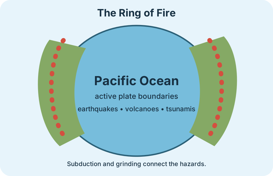
The Ring of Fire is the pattern of earthquakes and volcanoes around the edges of the Pacific Ocean. The Pacific Plate is being pushed beneath several surrounding plates. Subduction melts rock, rising magma forms volcanoes, and grinding plates cause earthquakes.

Why the Ring of Fire burns (2)

Underwater earthquakes can create tsunamis. In deep water, tsunami waves begin small and far apart, so they are hard to notice. They slow down and grow taller as they reach shore. Earthquakes usually last less than 60 seconds, but aftershocks can continue for days and damage structures already weakened by the first quake.

Why the Ring of Fire burns (3)

Earthquakes almost always come before volcanic eruptions, giving scientists an important warning sign. People still live around the Ring of Fire because Pacific ports support trade and because many coastal areas offer fishing, views, weather, and recreation.

Pacific Ocean surrounded by a ring of volcano and earthquake symbols
The pattern follows plate boundaries around the Pacific. One plate process connects the three hazards.
Likely on the quiz Use one cause chain: subduction and grinding → earthquakes and magma → volcanoes; an underwater earthquake can also start a tsunami.
Not sure about this bit?

Check your Rock Beneath knowledge

Answer one question at a time. The explanations point back to the assigned Apex studies and study sheets.

1 / 20 0 correct

Final checklist

Tick these off as you go. Saved in this browser.