The big ideaUnit 1 gives you a working geographer's toolkit: write about the world, think in spatial patterns, read map choices, and use five themes to ask better questions.
By the end you can
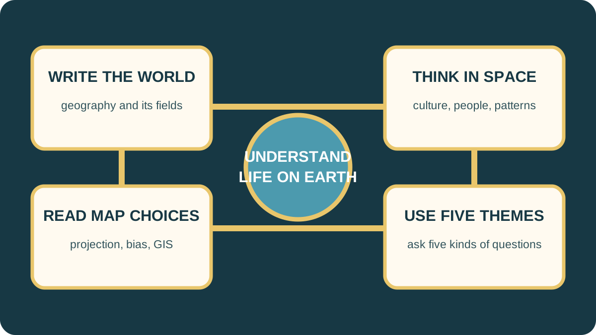
Connect the four parts of Unit 1: writing about the world, spatial thinking, maps, and five themes.
Rehearse both captured map-task variants and a five-theme migration organizer.
Answer the unit's short-response prompts about location and place, geography, GIS, and map bias.
Four folders for Unit 1
The review page organizes the unit into four parts so the terms and examples connect.
Not sure about the basics underneath this lesson?
Start with the four folders in Apex's review.
1
Words and space
Writing about the World names the field. Spatial Thinking looks for patterns in people, objects, culture, and population.
2
Maps
The Map Case covers purpose, projection, bias, mapmaking history, and GIS.
3
Themes
Five Themes asks five different questions about the same place or event.
Quick check β answer out loud before you peek
Which folder includes GIS and map bias?
The Map Case.
Got it now? Scroll back up and re-read the section β it should land differently.
The whole unit on one screen
Writing about the world introduces geography and its specialized fields. Spatial thinking examines where people and objects are, including mental maps, culture, population, and demographics. The Map Case studies map history, purpose, projection, bias, and GIS. Five Themes applies location, place, region, movement, and human-environmental interaction to real conditions.
The test asks you to connect the separate lessons, not only recite terms.
Likely on the quizApex's big question is: How does our study of the world help us better understand life on Earth?
Write and think spatially
Geography literally means βwriting the world.β The phrase fits because geographers describe and explain Earth's places, people, physical systems, and spatial patterns. Specialized fields include climatology, geology, meteorology, oceanography, and paleontology.
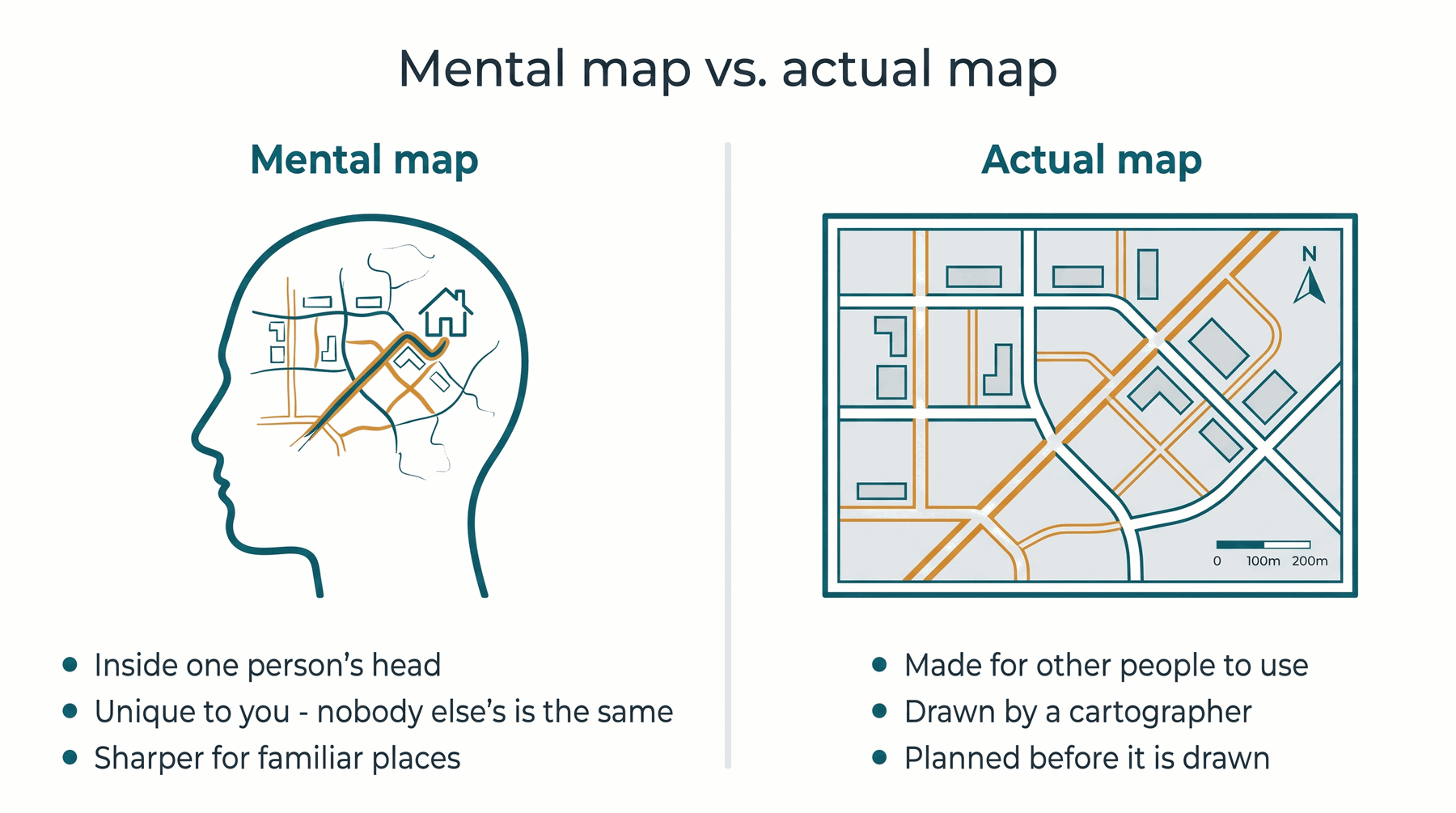
Spatial thinking focuses on the space people and objects occupy and the patterns they form. A mental map is an internal picture of the known world. Culture is a group's behaviors and beliefs. Demographics are definable characteristics of a population, while population density is people per unit of area.
A mental map is an internal rendering. A drawn map makes choices visible to other people.
Likely on the quizFor the geography short answer, give the literal meaning and then explain what geographers do in your own words.
Maps are choices
A map is useful because it leaves some information out and emphasizes other information. Its purpose and audience guide the title, symbols, scale, and features. A projection flattens Earth's curved surface, so some distortion is unavoidable. Bias is a leaning created by choices such as center, color, scale, projection, and omission.
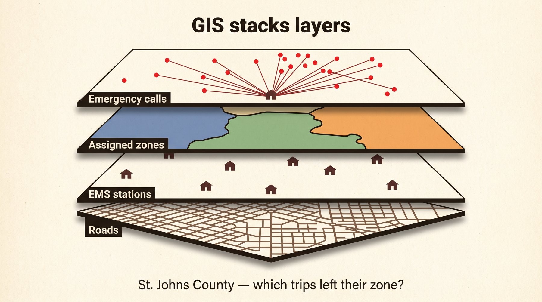
GIS changed geography by combining spatial locations with other data in complex computerized map layers. Landsat satellites support remote sensing.
GIS connects a location to several layers of information.
Likely on the quizBias does not automatically mean a map is false. Name the choice that causes the lean.
Five themes answer different questions
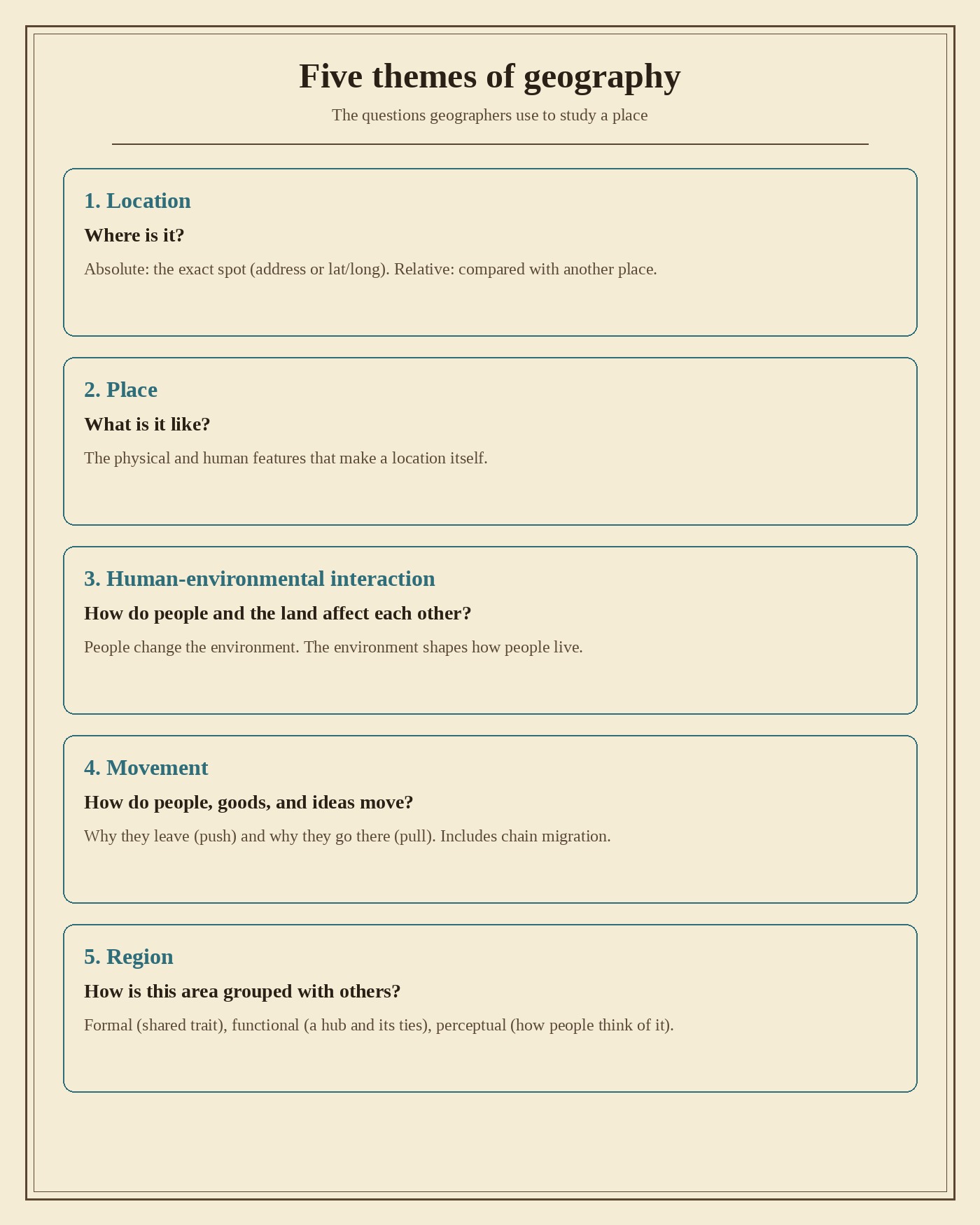
Location gives an exact or relative position. Place describes physical and human traits. Region groups places by unity, similarity, or connections. Movement follows people, goods, resources, and ideas, including push and pull factors. Human-environmental interaction examines how people modify, adapt to, and depend on the environment.
The teacher-scored task gives one migration and asks what each theme adds. Do not repeat the same sentence five times. Change the question with the theme.
One event can be understood five ways.
Likely on the quizLocation says where the migrants clustered. Movement explains why and how they moved. Place describes destination traits. Region groups the pattern. Human-environmental interaction connects work and settlement to the environment.
Rehearse the map task
Apex captured two different versions of the map task. Be ready for either, but do not mix their checklists.
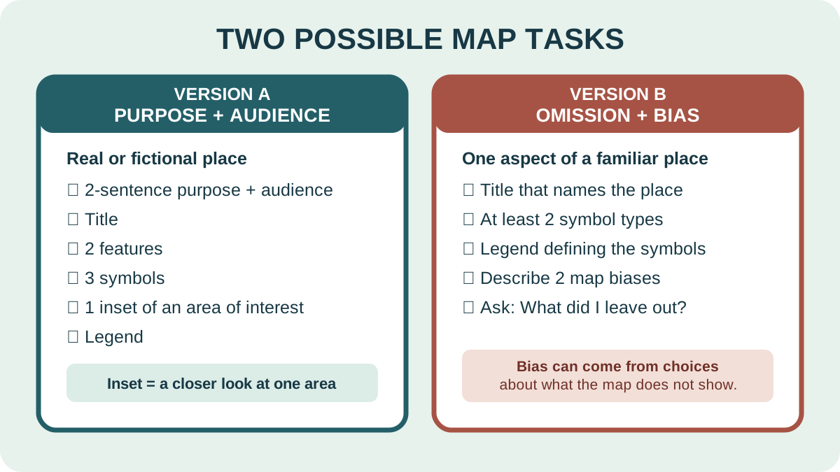
Version A β purpose and audience: draw a real or fictional place with a two-sentence purpose and audience, a title, two features, three symbols, one inset showing an area of interest, and a legend.
Version B β omission and bias: map one aspect of a familiar place. Give it a title that indicates the place, use at least two symbol types, define them in a legend, and describe two biases in the map. A bias may come from what you chose not to show.
First identify which version is on the test. Then write only that version's checklist in the margin and check off each requirement when it is visible.
Identify the version first. Version A needs purpose and audience; Version B needs a place-naming title and two described biases.
Likely on the quizA symbol without a legend entry is unfinished. An inset should enlarge an area of interest.
Not sure about this bit?
Write the checklist before drawing.
1
Version A
Purpose and audience, title, two features, three symbols, inset, legend.
2
Version B
One mapped aspect, title, two symbol types, legend, two biases.
3
Final scan
Match every symbol to the legend and every requirement to something visible.
Quick check β answer out loud before you peek
What does an inset do?
It enlarges an area of interest.
Got it now? Scroll back up and re-read the section β it should land differently.
Rehearse the migration organizer
The test may use Chinese immigration in the late 1800s or Irish immigration during the potato famine. Apex supplies a map and a short event description. Build one sentence per theme:
Location: Where does the map show a concentration?
Place: What physical or human traits mattered at the origin or destination?
Region: What larger area or cluster links the states?
Movement: What push, pull, route, work, or chain pattern explains the move?
Human-environmental interaction: How did work, resources, terrain, or adaptation connect people to the environment?
Use only facts in the test prompt and map. If the map does not show a fact, do not invent it.
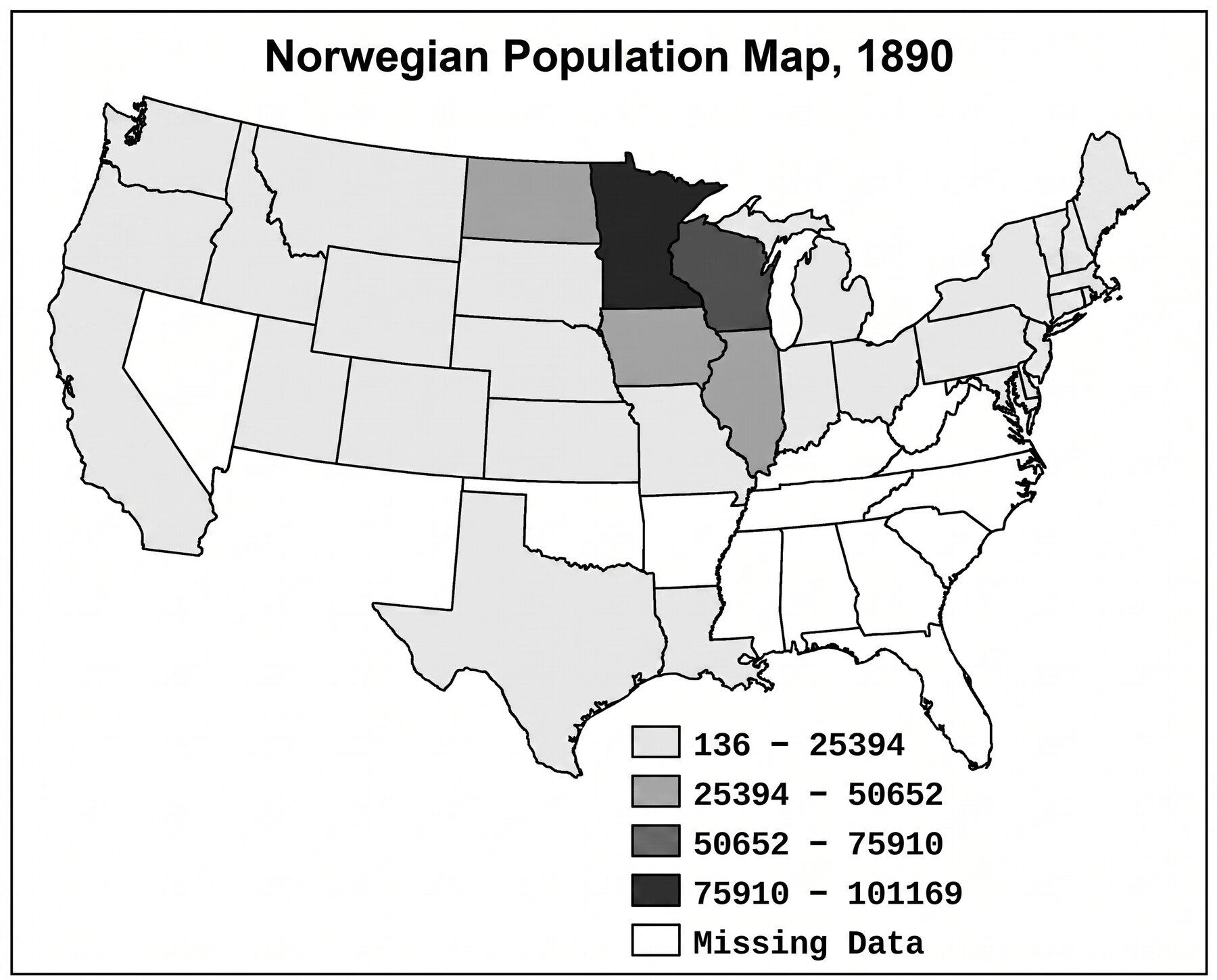
The lesson practiced all five themes with Norwegian migration. The test applies the same method to another migration.
Likely on the quizKeep cause and location separate: a dark state on the map is evidence of location, not automatically a reason for moving.
Not sure about this bit?
The migration stays the same. The question changes five times.
1
Where and what
Location finds the cluster. Place describes useful physical or human traits.
2
Group and move
Region explains the larger pattern. Movement uses push, pull, route, work, or chain migration.
3
Interact
Human-environmental interaction connects settlement or work to resources, terrain, adaptation, or modification.
Quick check β answer out loud before you peek
Does a dark state on the map prove why people moved?
No. It shows location. A cause needs evidence from the prompt or course.
Got it now? Scroll back up and re-read the section β it should land differently.
CST and TST quick check
One question at a time. This covers the review index and the captured test task shapes, not a hidden Apex question bank.
Use explanations to decide what needs one more pass.