Unit 1 · Introduction to Geography · Lesson 1.3 The Map Case
The big ideaThis lesson is a reading, not a new map to draw. Sailors 500 years ago already used the same latitude and longitude grid you learned in 1.3.2. The hard part was using that grid at sea. Latitude they could measure. Longitude they mostly guessed. Your job is to fill the reading guide from one secondary-source essay.
By the end you can
Name the five things the essay says map accuracy depends on, and which problem the essay spends most of its time on.
Explain why 16th-century sailors could measure latitude but not longitude, and name the three main marine tools.
Tell a primary source from a secondary source, and use the essay to finish the reading guide.
Before you start: the grid you already know
This reading uses latitude and longitude the same way 1.3.2 did. Open this if "they had the grid but still got lost" sounds like a contradiction.
Not sure about the basics underneath this lesson?
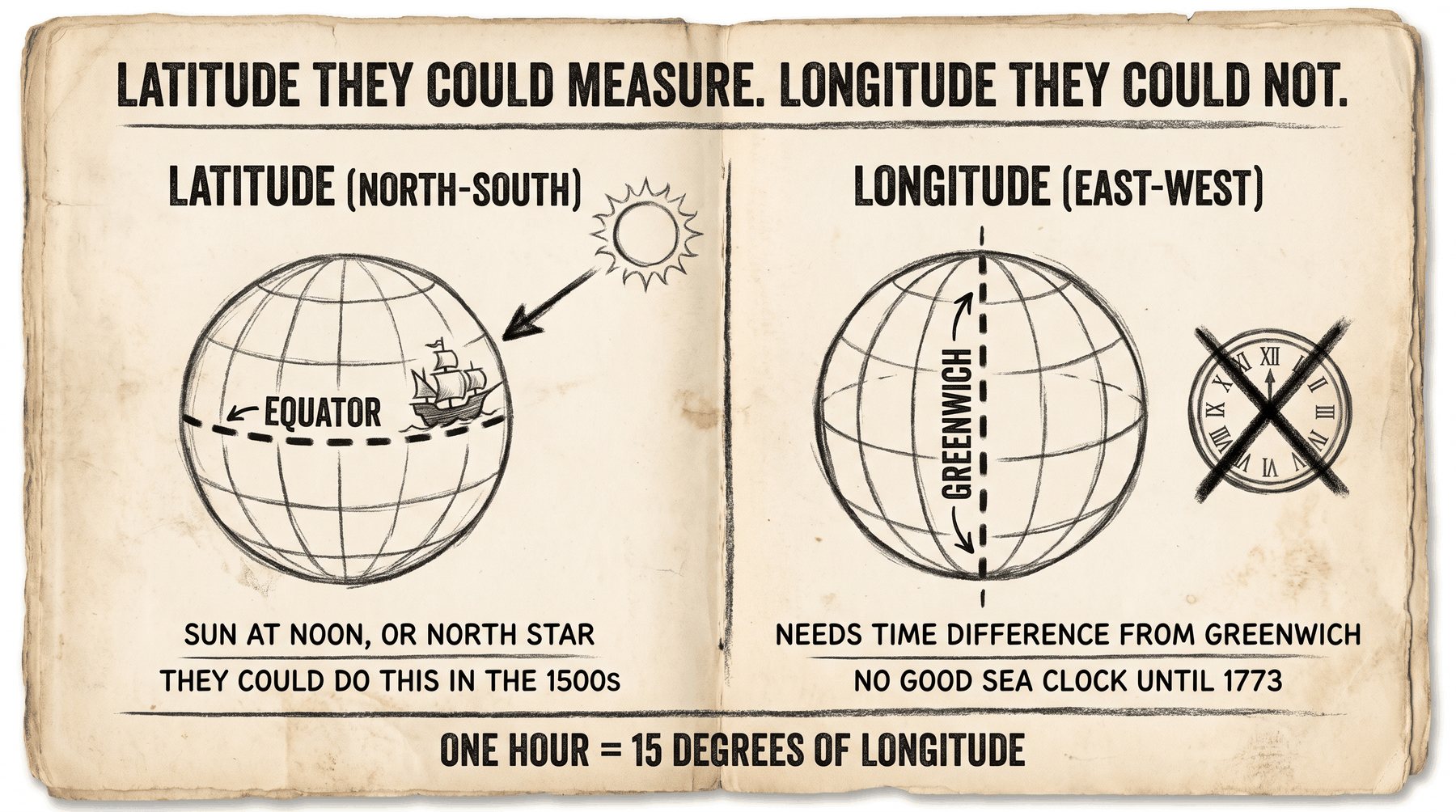
Latitude is north or south. Longitude is east or west. Sixteenth-century sailors already agreed to write position that way. The catch: they could measure latitude from the sun or the North Star. They could not measure longitude without a clock that still told Greenwich time after weeks on a rolling ship. So they guessed east-west distance, and they crossed oceans by holding one latitude line.
1
Same grid, half of it missing at sea
If you can plot 30° N, 90° W from 1.3.2, you already know the language. This lesson is about which of those two numbers a 1500s navigator could actually check from the deck.
2
Time is longitude
Earth spins 360° in 24 hours, so one hour = 15° of longitude. Noon here vs noon in Greenwich is your east-west position. No clock, no number.
3
This page is a secondary source
You are not reading a captain's log. You are reading a later essay that explains many logs at once. That is why Apex can ask you for five accuracy factors and three tools in one sitting.
Watch someone else explain it
What IS Longitude? — BBC Earth Science — About four minutes. Shows why longitude needs a clock, and why a clock at sea was the hard invention. The essay dates that clock to 1773 (Harrison). Your assigned century is the 1500s, before that clock existed.
Quick check — answer out loud before you peek
A sailor in 1550 knows he is 45° north. Why does he still not know how far west of Portugal he is?
45° north is latitude (sun or North Star). West of Portugal is longitude. That needs a time difference from a home meridian, and he does not have a clock that keeps that time at sea.
Got it now? Scroll back up and re-read the section — it should land differently.
This is a reading, not a new map type
Apex sends you to an essay on Library and Archives Canada: The Mapmakers: An Essay in Four Parts, the page titled Mapmaking: 16th Century. The activity says you are only responsible for that first page, not the 17th-century, 18th-century, or map-production pages.
This is a reading, not a new map type (2)
Print (or copy) the reading guide first. Identifying the document is part of the guide: what is this, who made it, when, and is it primary or secondary?
This is a reading, not a new map type (3)
The essay is a secondary source. It is not a 1500s ship's log. It is a later writer explaining what navigators and mapmakers were up against. Apex page 4 adds: most of those ships were sailing for profit (moving goods), not to draw pretty maps. Accurate maps still mattered, especially once people were going to places that were new to them.
Likely on the quizIdentifying the document: a secondary-source essay (2001, Library and Archives Canada / Pathfinders and Passageways) about 16th-century mapmaking. Not a primary log from a captain.
Five things that make a map accurate
The essay starts with the job of a map: a scaled-down picture of Earth's surface. Maps of land, charts of coasts. They prove a discovery happened and let someone else follow.
Five things that make a map accurate (2)
Maps are built from three measurable pieces: location, direction, and distance. Some maps also add symbols and elevation.
Five things that make a map accurate (3)
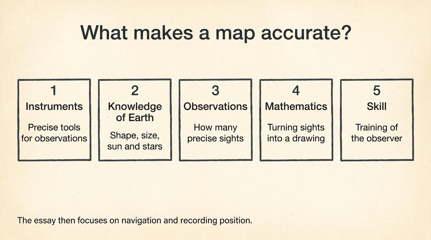
Accuracy depends on five things. These are the list for reading-guide question 1: 1. How precise the instruments are 2. What the observer knows about Earth's shape and size, and how Earth lines up with the sun and stars 3. How many precise observations went into the map 4. The math used to turn observations into a drawing 5. The skill and training of the observer
Five things that make a map accurate (4)
Which of the five does the essay spend most of its time on? Navigation and recording position: instruments, latitude, longitude, and the guesses they had to make at sea. Apex says that in so many words on page 4.
Reading guide Q1. Learn the five. The essay then lives in instruments and observations, not in a long lecture on math class.
Likely on the quizWrite the five in the essay's order. Then one sentence: it focuses on navigation and recording (instruments, lat/long, dead reckoning), not on printing or art.
Not sure about this bit?
Five items on the reading guide. Say them in the essay's order.
1
Tools and the person using them
Precise instruments, plus the observer's skill and training. A good astrolabe in untrained hands still makes a weak map.
2
What they know, and how many times they measured
Knowledge of Earth's shape and the sky, and a pile of precise observations, not one lucky sighting.
3
The math that turns sights into a drawing
The fifth piece is mathematics. The essay does not stay there. It stays on how they measured at sea.
Quick check — answer out loud before you peek
Name the five. Which one is the essay mostly about?
Instruments, knowledge of Earth and sky, number of observations, math, skill. The essay is mostly navigation and recording: instruments, lat/long, dead reckoning.
Got it now? Scroll back up and re-read the section — it should land differently.
Latitude they could measure
By the 16th century there was a general agreement to record position by latitude and longitude. That is reading-guide question 2. The century is the 1500s, not the 1700s when the clock finally worked.
Latitude they could measure (2)
Latitude was the part they could actually do. The Earth's axis stays in a steady relationship with the sun and stars. Measure the sun's height at noon and correct for the day of the year, or measure the height of the North Star (Polaris) and nudge a little because Polaris is not exactly on the geographic pole.
Latitude they could measure (3)
Jacques Cartier's 16th-century latitudes were good to about one-quarter to one-half of a degree. One degree of latitude is about 111 km.
Likely on the quizQ2 answer is the 16th century. Do not put 1773 here. 1773 is when longitude got a clock, much later.
Longitude they could not
This is the hole in the grid. Longitude is the angle between a place, Earth's axis, and a prime meridian (today, Greenwich). Geographers had known since the ancient Greeks that you get longitude from the difference in solar time between two places. Earth is 360° around and spins once in 24 hours, so one hour equals 15° of longitude. One degree equals four minutes of time (about 111 km at the equator).
Longitude they could not (2)
You need a clock that still tells Greenwich time after weeks at sea. Time-pieces were not generally available until late in the 18th century. The essay says accurate longitude waited for John Harrison's marine chronometer in 1773.
Longitude they could not (3)
So 16th-century sailors estimated east-west distance instead. On land: how far an average man could walk in an hour (one league, about five kilometres; the French lieu d'une heure de chemin). At sea: estimated ship speed turned into distance. That whole guess-and-plot habit is dead reckoning. The navigator wrote speeds, course changes, and currents in a log, then plotted them with the compass.
Latitude: sun or North Star. Longitude: needs a clock they did not have. Dead reckoning filled the gap, badly.
Likely on the quizQ3: the difficulty is longitude. They could not keep accurate time at sea, so they could not turn a time difference into east-west position.
Not sure about this bit?
If latitude is a sighting, longitude is a clock.
1
The arithmetic
360° around, 24 hours around. One hour = 15°. One degree = four minutes of time.
2
What they did instead
Dead reckoning: estimate speed, write it in the log, plot distance. On land they even used walking time (about five kilometres an hour).
Quick check — answer out loud before you peek
Why is 1773 the wrong answer to "when did they agree to use lat/long"?
They agreed to the grid in the 16th century. 1773 is when Harrison's chronometer made longitude measurable. Two different questions.
Got it now? Scroll back up and re-read the section — it should land differently.
Three tools, and the one they trusted
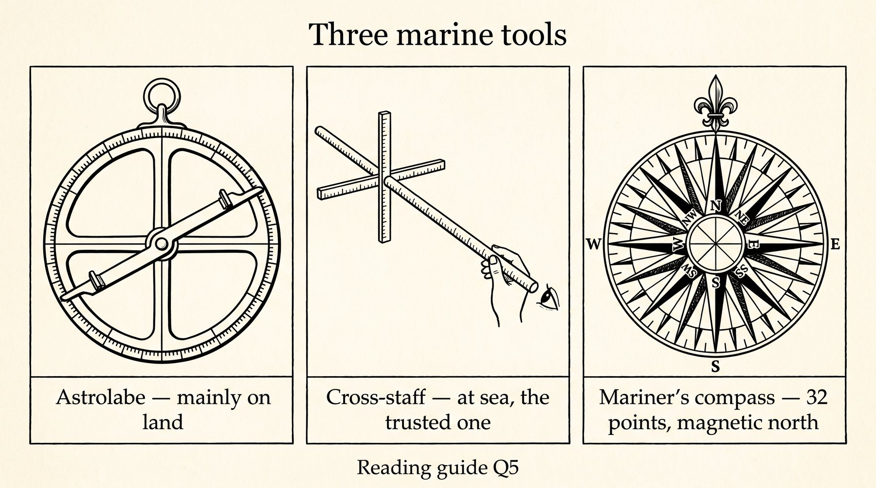
The essay's three main marine tools: • Astrolabe — height of the sun or a star, used mainly on land • Cross-staff (Jacob's Staff) — the sea version of that measurement • Mariner's compass — 32 points, not degrees. Each point is 11°15'
Three tools, and the one they trusted (2)
Which was the most trusted? The essay is blunt about latitude sailing: the captain used the one instrument he trusted, his cross-staff, to stay on the chosen latitude.
Three tools, and the one they trusted (3)
The compass was in general use, but it was a messy tool. It points at the magnetic pole. Maps are drawn on true north. That gap is magnetic declination, and it also changes with place and with time. Few 16th-century mariners knew how to correct it, or cared. Compass bearings on those maps tend to be magnetic bearings, so the whole map looks slightly twisted to a modern reader.
Astrolabe on land, cross-staff at sea (the trusted one), compass with 32 points. Reading guide Q5.
Likely on the quizQ5: astrolabe, cross-staff, mariner's compass. Most trusted: cross-staff. If you write chronometer, that is 1773, not this century.
Not sure about this bit?
Three names. One of them is the trusted one on a crossing.
1
Astrolabe vs cross-staff
Both measure how high the sun or a star sits. Astrolabe: mainly land. Cross-staff (Jacob's Staff): at sea, and the one they trusted.
2
Compass last
Useful, in general use, 32 points. It points magnetic north, maps use true north, and few sailors fixed that. Do not call it the trusted tool.
Quick check — answer out loud before you peek
Someone answers Q5 with "compass, GPS, and clock." What should they write instead?
Astrolabe, cross-staff, mariner's compass. Most trusted: cross-staff. GPS and the chronometer are later.
Got it now? Scroll back up and re-read the section — it should land differently.
Latitude sailing: the workaround
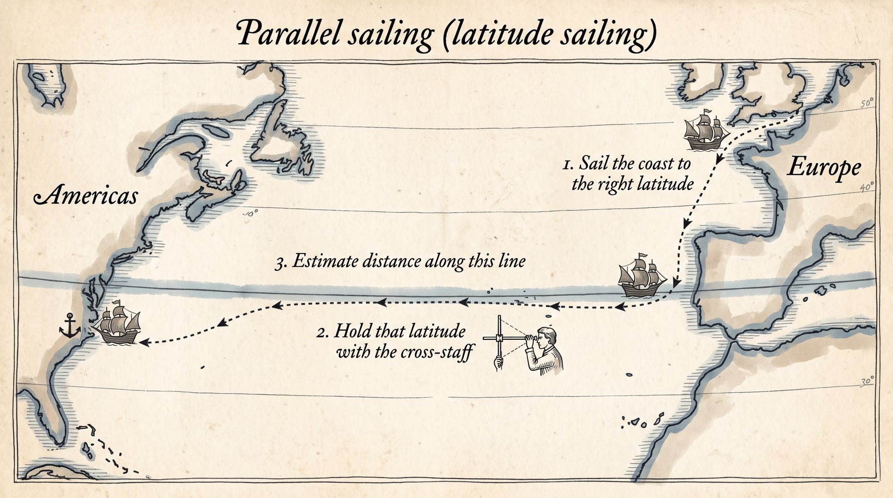
Direction and distance over open ocean were both guesses. So most 16th-century navigators cut the guesswork with parallel sailing (latitude sailing).
Latitude sailing: the workaround (2)
1. Sail along the European coast until you reach the latitude of the place you want. 2. Leave the coast and hold that same latitude all the way across, checking with the cross-staff. 3. Estimate distance along that fairly straight line. That distance becomes the gap on the map between Europe and the destination, along that one parallel.
Latitude sailing: the workaround (3)
Tables then let them mark meridians (longitude lines) for that latitude. The more often they ran the route, the better the observations got. Close to shore they took compass bearings of the coast, estimated distances, and, if the weather allowed, calculated latitudes. Bays, river mouths, hills got sketched as they passed. Those rough surveys are what most 16th-century maps are built from.
Latitude sailing: the workaround (4)
One extra trick: the rule "to raise or lay a degree of latitude," an early form of plane sailing with right triangles. Cross one degree of latitude with the cross-staff, look up distance sailed and east-west distance in a table. Trigonometry later made the tables unnecessary. The essay says more accurate maps with better instruments wait until the early 17th century, when people were hunting harbours and places to settle.
Parallel sailing: get on the right latitude first, then hold it across. That is how they crossed an ocean without a longitude clock.
Likely on the quizIf Q6 asks which solution interested you, latitude sailing is a strong pick: they used the one measurement they could trust (latitude) and refused to depend on the one they could not (longitude).
Why a secondary source helps here
Apex is explicit: this course mostly uses primary sources. This activity is the exception on purpose.
Why a secondary source helps here (2)
A primary source is someone recording what they know directly (a log, a letter, a diary). A secondary source is someone later talking about other people's experiences. This essay is the second kind.
Why a secondary source helps here (3)
Advantage of the secondary source on this topic: one short essay can pull together many voyages, tools, and problems. You see the whole pattern (latitude works, longitude does not, so they sail the parallel) without having to read every captain's log in 16th-century language. The cost is that you are reading an interpretation, not the raw log.
Why a secondary source helps here (4)
Q4, main purpose of the essay: to explain the problems 16th-century navigators and mapmakers had recording position, the tools they used, and the workarounds (especially dead reckoning and latitude sailing). Apex's own setup line is the same: problems, solutions, tools.
Likely on the quizQ7: secondary source = one clear picture of the problem across many trips. Primary source = closer to one person's voyage, harder to see the pattern.
Your reading guide
The notes to write on the reading guide.
Your reading guide (2)
Identifying the document. What: a later essay about 16th-century mapmaking, the page titled Mapmaking: 16th Century (Library and Archives Canada / Pathfinders and Passageways). Who: a later writer, not a 1500s captain. When: 2001 archive essay. Primary or secondary: secondary.
Your reading guide (3)
1. Five things accuracy depends on. Instruments. Knowledge of Earth's shape and size, and the sun and stars. How many precise observations. The math. The skill and training of the observer. The essay spends most of its time on navigation and recording position (instruments, latitude, longitude, dead reckoning).
Your reading guide (4)
2. Lat/long agreement: the 16th century.
Your reading guide (5)
3. The difficulty: longitude. It needs accurate time at sea, and they did not have a clock that kept Greenwich time. Latitude they could measure.
Your reading guide (6)
4. Main purpose: explain the problems, tools, and workarounds 16th-century navigators and mapmakers used to record position.
Your reading guide (7)
5. Three marine tools: astrolabe (mainly land), cross-staff (sea, the trusted one), mariner's compass (32 points, magnetic).
Your reading guide (8)
6. A solution you can pick: parallel sailing (hold one latitude across the ocean with the cross-staff), because they used the measurement they could trust and avoided the one they could not. Your reason can be that, in your own words.
Your reading guide (9)
7. Advantage of a secondary source: one essay can pull many voyages and tools into one clear picture. The cost is that you are reading an interpretation, not a raw log.
Likely on the quizQ6 is the one that wants your pick. The others have a course answer.
Not sure about this bit?
Seven numbered questions plus the document box. Write these.
1
The document
Secondary-source essay, 2001, first page only: Mapmaking: 16th Century.
2
Q1–Q3
Five accuracy factors; essay focuses on navigation. Lat/long agreed in the 16th century. The hole is longitude (no clock).
3
Q4–Q7
Purpose: problems, tools, workarounds. Tools: astrolabe, cross-staff (trusted), compass. Q6 is your pick. Q7: one essay, many voyages.
Quick check — answer out loud before you peek
Most trusted marine tool in the essay?
The cross-staff.
Got it now? Scroll back up and re-read the section — it should land differently.