What you need
- The printed practice pages (the print icon is on the assignment page in Canvas)
- A pencil
- This page
No internet and no atlas until question 2c. That is the worksheet's own rule, and it is also the point of the assignment. The skill is the counting, not the looking up.
The one move
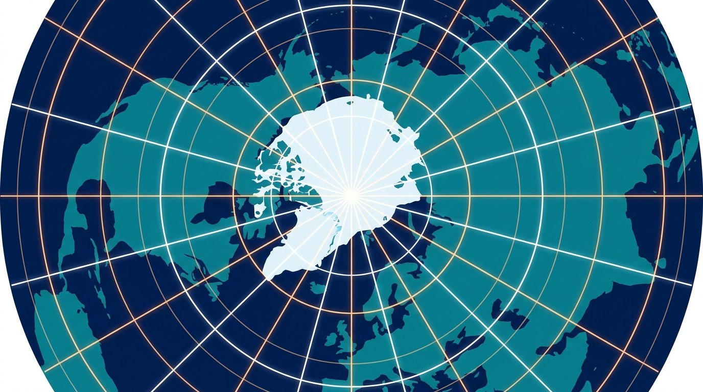
Your worksheet map looks strange because it is not a flat map. It is a drawing of the globe seen from above, and the artist tilted it a little. The North Pole is the point where all the spoke lines meet, up toward the top of the circle, not at its exact middle.
On a normal map, latitude lines run sideways and longitude lines run up and down. On this round map the same grid is curled up:
- Latitude = the rings. Counting rings means counting out, away from the pole.
- Longitude = the spokes, like pizza slices. Counting spokes means counting around the circle.
So every coordinate, like 30°S, 90°E, is just two counts: out to the ring, around to the spoke, and the dot goes where they cross. Question 1 does it forward (numbers to a dot). Question 2 does it backward (a city to its numbers). Same move both times.
One warning before you start: on a circle, "east" is not "to the right." It points a different way depending on where you are around the rim. So we navigate by landmarks instead: east means counting around the bottom, toward Asia and Australia. West means counting up over the top, toward the Americas.
Number your map, once
Everything on the worksheet starts with writing the numbers onto the grid lines on your printed map. The wheel below shows your worksheet's own map. Click through the steps: each one highlights the line you are numbering next, on the real map, so you can find the same line on your paper and copy the number onto it.
- 90°N at the spoke crossing. The point where all the spoke lines meet is the North Pole. On this drawing it sits up toward the top of the circle, not exactly in the middle. Write 90°N there.
- Count the rings out by 15s. Starting at the pole, each ring outward is 15° less: 75°N, 60°N, 45°N, 30°N, 15°N.
- Check yourself with Africa. The ring that passes through the middle of Africa must be the equator, 0°. If your count lands there, you numbered the rings right. Label it 0°.
- Keep counting past the equator. The next ring out is 15°S, and the outer edge of the map is 30°S. Notice the edge cuts through the bottom of Africa and through Australia, that is how you know it is 30°S.
- Find the 0° spoke. One spoke runs through England (the UK) and down through West Africa. That is the prime meridian, 0°. Label it.
- Count the spokes by 15s. Starting from 0°, count spokes around the bottom of the map, sweeping toward Asia and Australia: 15°E, 30°E, 45°E, and so on. That direction is east. Counting the other way, up over the top toward the Americas, is west: 15°W, 30°W, and so on.
- Check the spokes with landmarks. The 75°E spoke should pass right through India. The 30°E spoke should pass through southern Africa. The 120°E spoke should land on western Australia. If yours do, the numbering is right.
That was the hard part, and it only happens once. Every question now comes down to the two counts.
Try one that is not on your worksheet
Practice on 60°N, 90°E so the real four stay yours:
- Ring: start at the pole and count out. 90, 75, 60. Stop on the third ring, that is 60°N.
- Spoke: from the 0° spoke (the one through England and West Africa), count around the bottom toward Asia. 15, 30, 45, 60, 75, 90. Stop on the sixth spoke, that is 90°E.
- Where your 60°N ring crosses your 90°E spoke, make a dot. It lands inside the huge landmass of Asia, way up in Russia's north (Siberia).
Two counts, one crossing, one dot. That is the whole assignment.
Question 1: numbers to dots
1a + 1b (4 points). Do the two-count move for each pair on your paper. Number the dots 1 to 4, then write the continent or ocean next to each one in the chart.
- 30° S, 90° E
- 45° N, 105° E
- 60° N, 105° W
- 25° S, 120° E
Check your dots after you have plotted them yourself
- 30°S, 90°E → the edge ring, 6 spokes east → in the ocean west of Australia: Indian Ocean
- 45°N, 105°E → 3 rings out, 7 spokes east → the Mongolia and north China area: Asia
- 60°N, 105°W → 2 rings out, 7 spokes west, up over the top → northern Canada: North America
- 25°S, 120°E → almost to the edge, 8 spokes east → right on Australia
If one of yours disagrees, recount that point's ring and spoke. A slipped count is almost always the whole problem.
1c: the 8-point explanation
The big points are for telling the story of one dot, in your own words. Five pieces to hit:
- Where you started (the pole, 90°N)
- How you counted the rings (by 15s)
- How you knew the count was right (the Africa or equator check, or the 30°S edge through Australia)
- How you counted the spokes (from the England and West Africa spoke, which direction, by 15s)
- What the dot landed on
Here is a full example, written for the practice dot so it cannot be copied onto your sheet:
I started at the North Pole, the point where all the spokes meet, which is 90°N. The rings are 15° apart, so I counted out to the third ring: 75, then 60, so that ring is 60°N. I knew my ring count was right because the ring through the middle of Africa landed exactly where 0° should be. For longitude, I found the spoke through England, which is 0°. East goes around the bottom of the map toward Asia, so I counted six spokes that way: 15, 30, 45, 60, 75, 90. Where the 90°E spoke crosses the 60°N ring, I drew my dot. It is inside Asia, so 60°N, 90°E is in Asia.
Yours should be about one of your four dots, with your real counts. A small rough sketch next to it is welcome.
Question 2: cities to numbers
2a (4 points). Same move in reverse. Find the city on the map like you would on any map, by its continent and coastline. Then read the grid: which ring is it closest to, and which spoke. The question says "approximate," so reading to the nearest 5° is right.
Here is the reverse move on a city that is not in your four: Delhi, India. India is the big triangle hanging down from Asia, toward the bottom of the map. Delhi is in northern India, so it sits just inside the 30°N ring: latitude about 30°N. For longitude it lies between the 75°E and 90°E spokes, nearly on the 75°E one, so about 75 to 80°E. Done. (The exact answer, for later comparison, is 28.6°N, 77.2°E. The grid only lets you estimate, which is why the question says approximate.)
Now yours. Landmark hints, no numbers yet:
- Tokyo, Japan: Japan is the chain of islands off Asia's east coast, on the right side of the map
- Johannesburg, South Africa: the very bottom tip of Africa, almost at the map's edge
- Colombo, Sri Lanka: Sri Lanka is the small teardrop island hanging just off India's southern tip
- Berlin, Germany: in Europe, well above (toward the pole from) the middle of Africa
Check your estimates after you have written your own
- Tokyo → between the 30°N and 45°N rings and between the 135°E and 150°E spokes → about 35°N, 140°E
- Johannesburg → just inside the 30°S edge, near the 30°E spoke → about 25 to 30°S, 30°E
- Colombo → between the equator and the 15°N ring, near the 75 to 80°E spoke → about 5 to 10°N, 80°E
- Berlin → between the 45°N and 60°N rings, nearly on the 15°E spoke → about 50°N, 15°E
2b: the other 8 points
Same storytelling game as 1c, for one city. How you spotted the place, how you read the ring, how you read the spoke, and why the numbers are approximate:
I found Delhi by finding India, the big triangle that hangs down from Asia toward the bottom of the map. Delhi is in northern India. The nearest latitude ring was 30°N, and the city sits just inside it, so I wrote about 30°N. For longitude, Delhi sits between the 75°E and 90°E spokes, closer to 75°E, so I wrote about 75 to 80°E. The map only has lines every 15 degrees, so my numbers are close estimates, not exact.
2c: the one lookup
Now the internet is allowed, for exactly one question. Go to latlong.net, type one of your four cities (Tokyo works well), and copy its exact latitude and longitude into 2c. It is worth glancing at how close your estimate came.
Turn it in
- Four dots plotted and numbered 1 to 4 (1a)
- Chart columns filled: continent or ocean (1b)
- Written explanation for one dot, full sentences (1c, worth 8 on its own)
- Four cities with approximate coordinates (2a)
- Written explanation for one city (2b, another 8)
- One exact lookup from latlong.net (2c)
The two written explanations are 16 of the 25 points, so give them real sentences, not one word answers. Photo or scan your pages and submit in Canvas: Submit Practice: The Global Grid (1.3.2).